InSea visualizes the underwater world using point cloud technology
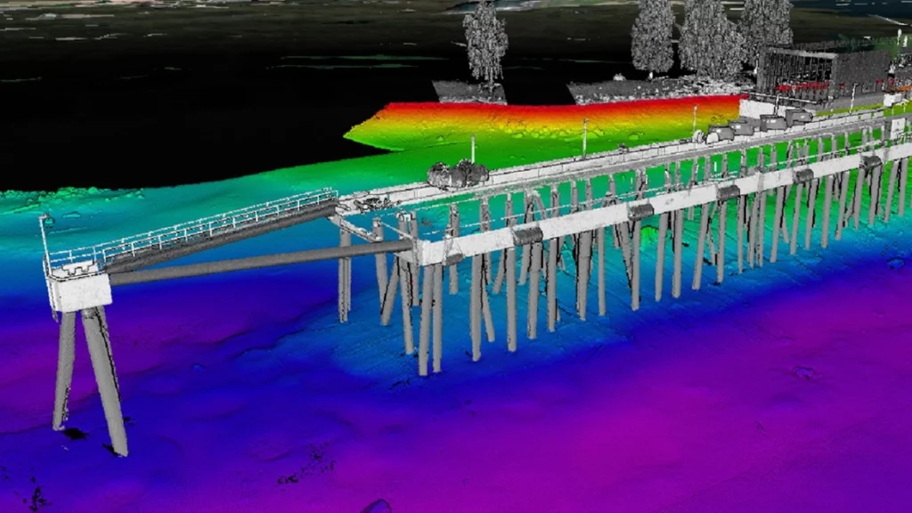
Known for its expertise in smart infrastructure, mobility, and cities, Nodeon has also been involved in numerous maritime digitalization projects. One of these is the InSea project by Arctia Meritaito Oy.
InSea is a digital management platform for maritime services developed by Arctia, a state-owned company in Finland. The InSea system, implemented by Nodeon, provides a maritime situational awareness ranging from real-time movements of AIS vessels to the status of fairway safety devices, port services, and more. According to Tero Tuominen, Development Director of Digital Solutions at Arctia, the purpose of the service is to help Arctia’s customers enhance the safety and operations of maritime activities.
“Working with point cloud data and large datasets generated through scanning in various infrastructure projects is one of our areas of expertise”
Joel Kuusela, Software & IoT Manager, Nodeon
One of the services implemented by Nodeon in the InSea system is a 3D map view, which is an accurate model of the seabed’s depth relationships, underwater landscape and structures. With this information, Arctia’s customers, such as ports and cities, receive valuable data for fairway management, port development, and maintenance.
“For instance, having access to the underwater situational picture is essential when conducting condition assessments of structures. This early insight can significantly influence the costs of repair and construction,” explains Tuominen.
What is a point cloud?
A point cloud is generated when the environment is 3D-modeled either by laser scanning or underwater multi-beam sonar. A point cloud is thus a three-dimensional dataset of a space or area, consisting of millions of individual observations.
“The creation of point cloud through scanning and sonar, the associated technologies, managing vast datasets, and the visualization tools forms a challenging technological field”, says Joel Kuusela, Manager for IoT and software at Nodeon.
“This technology streamlines the hydrographic processes. Point cloud data can be visualized, measured, stored, and shared in the service provided by Arctia, which is also available in a mobile version”, Kuusela continues.
The InSea system also provides index-like information about where and when measurements have been made. The point cloud model makes it easy to plan new work and maintenance phases, as well as document changes in the underwater situational picture.
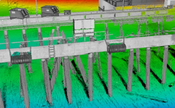
The laser-scanned 3D model has many applications
3D models of various areas and spaces can be utilized not only in maritime operations but also in the public sector and industry, such as in urban and architectural planning and construction.
In infrastructure construction, using 3D models for planning is already common. However, laser scanning of a site, for example, by drones flying overhead, produces a higher quality and more efficient model compared to manual measurements. During a project, the site can be scanned multiple times, which not only facilitates initial planning but also aids in project management throughout the construction phase. Additionally, the virtual model saves time and reduces the need for physical site visits.
Through the InSea project, Nodeon has gained specialized expertise in processing 3D-models.
“Working with point cloud data and large datasets generated through scanning in various infrastructure projects is one of our areas of expertise. We are happy to help explore how this technology can be applied for different purposes,” concludes Kuusela.
Learn more about our software services
Would you like to hear more?
Our experts are happy to discuss your needs further. Contact us!

Joel Kuusela
+358 40 5867 134
joel.kuusela@nodeon.com
Our work

InSea visualizes the underwater world using point cloud technology
Read more
Kuopio develops traffic situational awareness
Read more
Nodeon designs technical solutions for Lahti Southern Ring Road
Read more
Rantaväylä tunnel – robust road infrastructure in the middle of the city
Read more